Magnetic anomaly in Australia resembles the shape of the continent
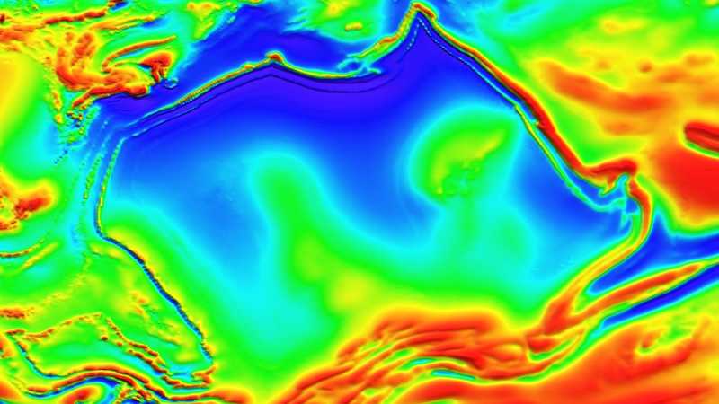
A curious discovery has caught the attention of the scientific community in Australia: geologists have mapped a strange magnetic anomaly in the Northern Territory that, in a striking coincidence, has a shape very similar to that of the Australian continent itself.
CONTINUA DEPOIS DA PUBLICIDADEThe so-called “Australia Magnetic Anomaly” appears to replicate striking features of the country’s map. It shows a kind of “point” to the north, similar to Queensland, reaches its greatest width in the central region, and has two extensions stretching southward on the eastern and western sides — an outline that surprisingly echoes the silhouette of Australia.
The detailed image of the anomaly was obtained during an aeromagnetic survey conducted by the Australian government. Small aircraft equipped with magnetometers flew over the region in parallel lines, spaced 400 meters apart. The instruments measure slight variations in the magnetic field, revealing the so-called remanent magnetization of underground rocks.

When rocks form, the magnetic minerals within them align with Earth’s magnetic field and “record” that orientation. Over millions and even billions of years, the planet’s magnetic field naturally changes — the poles shift and can even completely reverse. However, the rocks preserve this record, allowing scientists to reconstruct geological and magnetic changes that occurred in deep time.
CONTINUA DEPOIS DA PUBLICIDADE“Magnetic data allow us to see through the ground and understand geological structures that would otherwise remain completely hidden,” explains Clive Foss, a geoscientist at Australia’s national science agency, CSIRO. According to him, Australia’s shifting tectonic position over time, combined with the periodic reversals of Earth’s magnetic field, often causes remanent magnetization to point in unexpected directions, requiring specialized interpretation.
In this specific case, the anomaly originates from rocks formed by volcanic eruptions more than 1.5 billion years ago. These layers are interbedded with sandstones deposited in shallow seas and river deltas. Over time, geological forces folded and compressed these formations, shaping a structure that now resembles the outline of the Australian continent.
The new map is the most detailed ever produced for the region, revealing the features of the underground “magnetic landscape” with greater clarity. Part of this advancement is due to an innovative algorithm developed by Dr. Aaron Davis, a colleague of Foss, which refined the data and generated cleaner, more consistent images.
CONTINUA DEPOIS DA PUBLICIDADE“By improving the way we process and model these datasets, we’re able to extract more geological information than ever before,” Foss emphasizes.
The survey data are available in an open-access database maintained by Geoscience Australia. In addition to expanding scientific knowledge, the initiative may help identify new valuable mineral deposits in the region.
CONTINUA DEPOIS DA PUBLICIDADEQuer continuar acompanhando conteúdos como este? Junte-se a nós no Facebook e participe da nossa comunidade!
Seguir no Facebook